Cyclone Hidaya hits coast of Tanzania, impact to be felt in Kenya
Powerful winds at speeds exceeding 40 knots and significant ocean waves over two metres high are expected.
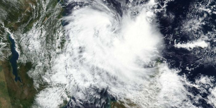
Tropical Cyclone Hidaya hit the coast of Tanzania on Saturday morning, with the Kenya Meteorological Department (Met) warning that its impact will be felt along the Kenyan coast.
Powerful winds at speeds exceeding 40 knots and significant ocean waves over two metres high are expected.
More To Read
- Weatherman warns of heavy rains, as Cyclone Chenge approaches Kenyan coastline
- Government activates nationwide emergency response amid heavy rain advisory
- China gives over Sh370 million in flood relief for Mathare school children
- State gives Sh1bn in April stipends to over 323,000 vulnerable families
- Isiolo, Kwale, Kilifi and Taita Taveta among 33 counties facing boundary conflicts
- Brace for intensified rainfall, strong winds on Monday and Tuesday - Met
"Current observations indicate that Tropical Cyclone Hidaya has made landfall on the coast of Tanzania. However, there is another depression developing behind it, which the department is monitoring keenly," the Met said on Saturday.
This is even as large waves hit the Indian Ocean.
"Strong winds may blow off roofs, uproot trees, and cause structural damage. Significantly large waves may affect marine activities. Updates will be provided promptly," Met Director David Gikungu stated in an advisory on Friday night.
The weatherman says the strong winds will also be felt in Mombasa, Tana River, Lamu, Kilifi, Kwale, Taita Taveta, and Garissa counties.
At the same time, heavy rainfall is expected along the coastal strip from Sunday, intensifying on Monday through Tuesday.
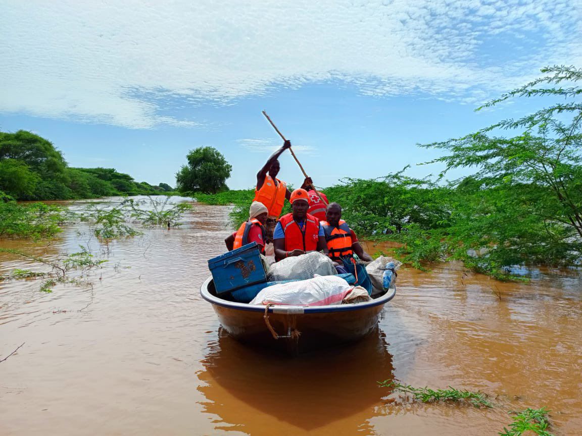 Members of the Kenya Red Cross Society on a rescue mission at the Konoramadha area of Saka, Tana River, on May 1, 2024. (Photo: Red Cross)
Hidaya's movements
According to the weather network, Cyclone Hidaya is a small but powerful storm, packing winds equivalent to those of a Category 1 hurricane.
"The storm will make landfall near the Tanzanian capital of Dar es Salaam during the early morning hours on Saturday. Strong winds are a secondary threat to the tremendous amount of tropical rainfall that'll push into the coast through this weekend," the agency said on Friday night.
It added that forecasters expect more than 200 mm of rain to fall around the Dar es Salaam region, which is home to more than five million people, with widespread flash flooding likely to occur across urban areas and along waterways throughout the region. Landslides and mudslides are possible in the hills west of the city.
"While the core of Hidaya's moisture will remain in Tanzania, the same onshore flow steering the cyclone into land will fuel additional rounds of tropical downpours north into flood-stricken areas of Kenya," the agency added.
The country recorded heavy rainfall on Friday night as the cyclone drew closer. The Kenya Red Cross Society has teamed up with the government to prepare and mitigate against death and destruction between Saturday and Monday.
On Saturday morning, the Tanzania Electric Supply Company Limited (TANESCO) announced a major blackout for most of the country due to the power grid's failure as the cyclone's intensity increased.
Scientists observe that it's rare for tropical cyclones to track this close to Tanzania, given the country's location just a few degrees south of the equator.
In the past, only four tropical cyclones on record have made landfall in Tanzania, and they all approached land with the equivalent strength of a weak tropical storm.
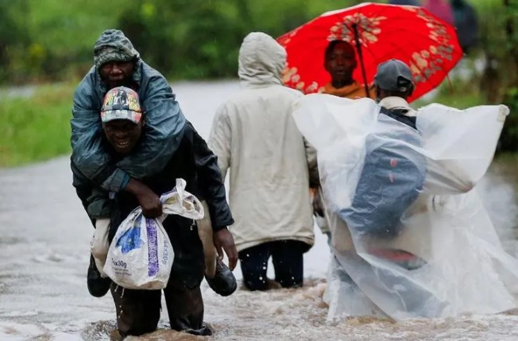
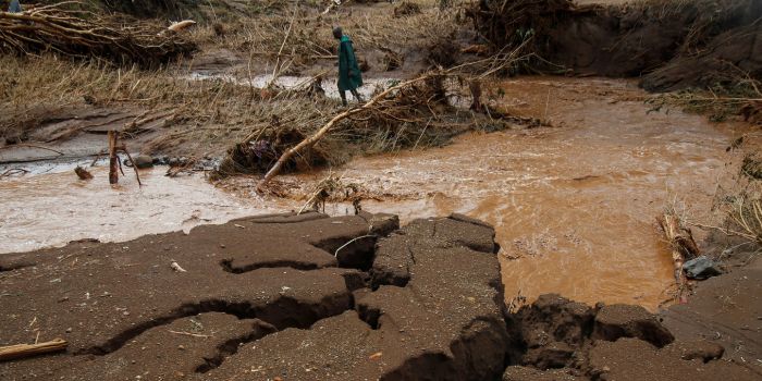 A member of the National Youth Service (NYS) searches for the bodies of missing people after flash floods wiped out several homes following heavy rains in Kamuchiri village of Mai Mahiu, Nakuru County, on May 1, 2024. (Photo: Monicah Mwangi/Reuters)
Back in Kenya, Nairobi residents of landslide- and mudslide-prone areas have been advised to be cautious and vigilant.
Heavy to very heavy rainfall and thunderstorms are expected to continue in 33 counties.
In the Western region, these are Kakamega, Vihiga, Busia, Bungoma, and Trans Nzoia, while in the Lake Victoria Basin, they are Kisumu, Kisii, Nyamira, Migori, Siaya, and Homa Bay. In the Rift Valley, Nandi, Bomet, Nakuru, Elgeyo Marakwet, West Pokot, Baringo, Samburu, Turkana, Uasin Gishu, Laikipia, and Narok will experience rain.
In the Central region, Nyeri, Muranga, Kirinyaga, Kiambu, and Nyandarua will experience heavy rain, while in the Eastern region, Machakos, Embu, Tharaka Nithi, Meru, and Marsabit will be affected.
"Flooding is expected in low-lying areas, riparian areas, and urban areas, while landslides and mudslides may occur in areas with steep slopes, escarpments, and ravines," reads the statement.
Residents of all the mentioned areas were advised to be on the lookout for potential floods, flash floods, and poor visibility.
Most parts of the North Eastern region (Isiolo, Garissa, Wajir, and Mandera) and the South Eastern region (Kitui, Makueni, Taita, Taveta, and Tana River) will be generally dry.
Favourable weather is expected in the North Eastern (Isiolo, Wajir, Mandera, Garissa) and South Eastern (Taita Taveta, Kitui, Tana River), which the CS said sets the stage for post-flood recovery initiatives in public works, the reconstruction of schools, repairs to water treatment systems, road repairs, and improvements to the accessibility of social and economic facilities.
The Kenya Coast Guard Service, responsible for marine operations in Kenya's territorial and inland waters, is on high alert and positioned in Kisumu, Tana River, Garissa, Kilifi, and Nairobi Counties to offer the required assistance.
The ministry also warned that the overflow of the Seven Forks Dams poses the risk of flooding in the Tana Delta, impacting Garissa, Tana River, and Lamu counties.
The water levels in rivers, lakes, and dams are expected to remain high, so it remains important to avoid driving or walking through moving water or open fields, and sheltering under trees and near grilled windows to minimise exposure to lightning strikes.
Top Stories Today